Subscribe to our mailing list
We are still here! Let us send you tips for travelling through Myanmar and stories from the road …
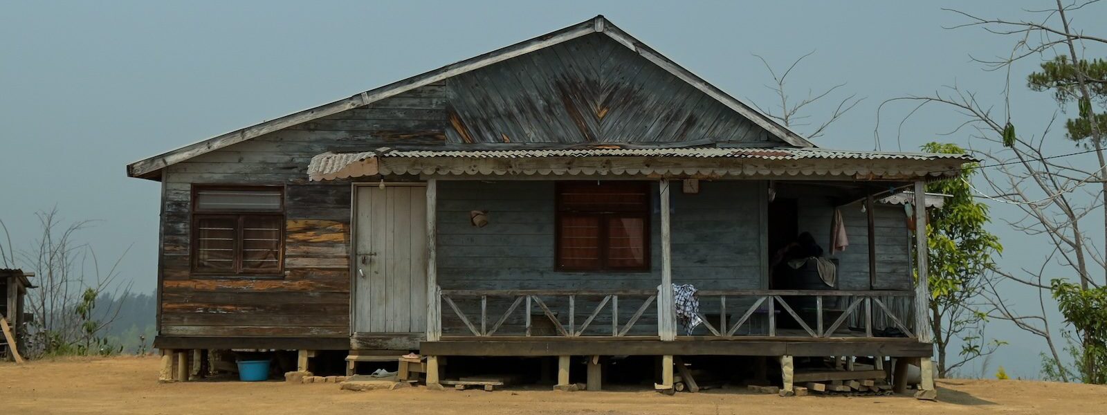
The Nagas are a collection of tribes of mixed origin and varying but similar cultures. The numerous Naga languages belong to the Tibeto-Burman group of the Sino-Tibetan language family. Nagaland’s history is as rugged as its terrain. From the migration of its tribes to its role in major global conflicts, the state’s legacy is one of resilience and spirit.
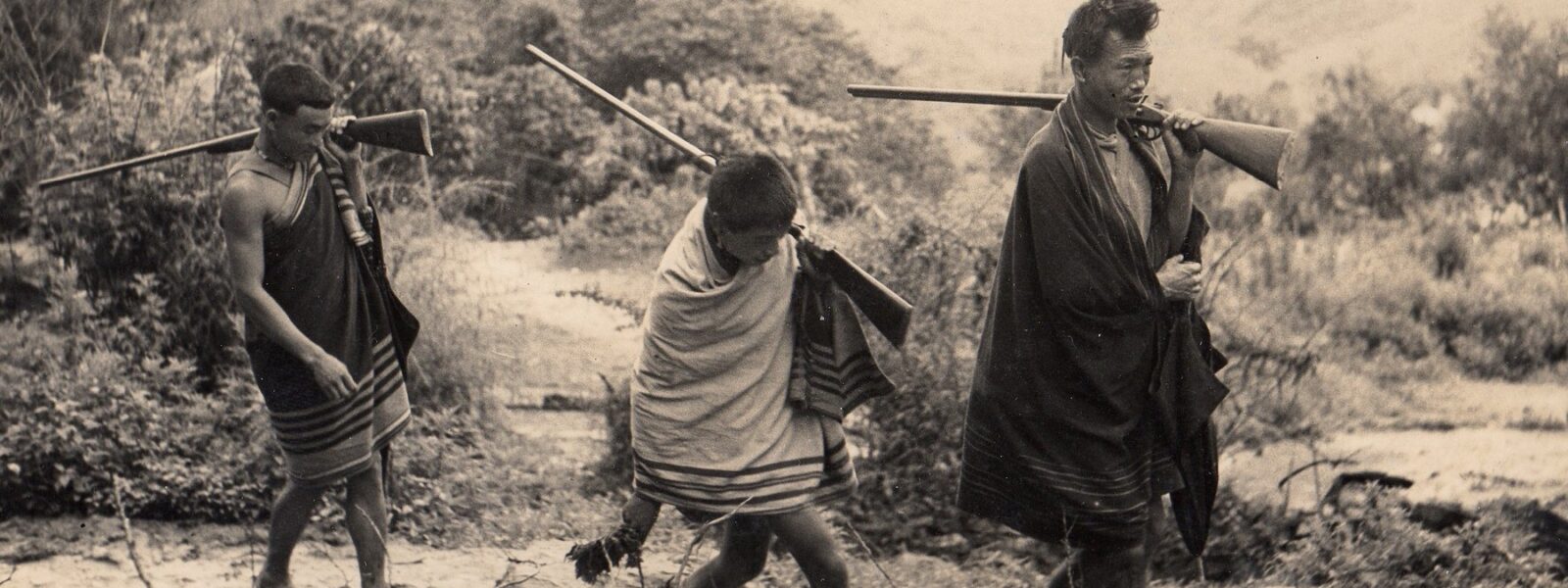
The Nagas are best known for their history of headhunting. This was largely – but not completely – stopped by the British, who turned up in the early 1800s and brought the Naga Hills very loosely into the Imperial bosom.
Today, any visitor to the town of Khonoma will be swiftly – and with more than a little pride – shown where early British imperialists were once speared. But there is no grudge, and international travellers to Nagaland – including Brits – will be welcomed with traditional Naga hospitality.
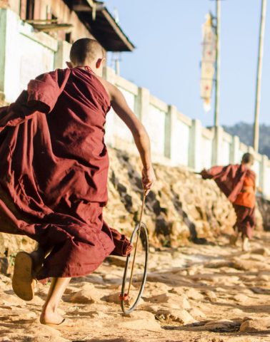
No journey to Nagaland is complete without savouring its traditional cuisine. The bold flavours of fermented bamboo shoot, the smoky allure of axone, and the fiery kick of the King Chilli make every meal an experience.
Nagaland’s natural beauty is as compelling as its cultural wealth but has been under threat for decades. For all their beauty, many breeds of animal have been hunted promiscuously for food and – increasingly – dubious potions that can be sold across the Chinese border. Nagaland’s national bird, the hornbill, has been hunted to extinction. The acreage of virgin rainforest is also decreasing, not just due to traditional slash-and-burn farming but also now because of logging. The proliferation of automatic weapons has also contributed to tipping the natural balance.
That being said, today there is much more awareness of the need to protect the natural environment. In Nagaland you will still find evergreen forests, mist-laden hills and valleys carpeted in wildflowers. For wildlife enthusiasts, Nagaland remains a haven, home to rare species like the Amur Falcon, clouded leopard and black bear.
Naga folklore and legends, as well as Naga mythology, tell that the Nagas first came from a place somewhere to the north in present-day China. They initially migrated to a village called “Makhrai-Rabu” where they dispersed to the various places they are living now.
The first written record of the Nagas dates back to the Ahom Kingdom (1228–1826) of modern-day Assam. It is believed that it was the Ahom who gave the Nagas their name, distinguishing them as mountain folk, quite separate to the valley-dwelling Assamese. Of this time, P.E. Ezung writes:
“The Naga people and culture were unknown to the outside world. The people lived a life that was very simple but rich in culture and tradition. Before the British invaded the Naga Hills, the only life the Nagas knew was living off the land in simplicity.”
In the mid-1800s, with the fall of the Ahom Kingdom, the Nagas came up against a new power.
The first cup of Assam tea was brewed and tasted in London in 1839. It was a big hit, and soon the forests of Assam were being cut down to make way for British tea plantations. When looking for a reliable route between Assam and the Kingdom of Manipur, the British began clashing with the Naga tribes in the hills.
Between 1839 and 1846, the British launched six major expeditions in an effort to subdue the Nagas. What followed was over three decades of intermittent warfare – arrows and stones hurled from the hills, met with bullets and artillery from the empire.
In her brilliant book, Land of the Dawn-lit Mountains, Antonia Bolingbroke-Kent quotes Major John Butler, a British Political Officer (“who travelled everywhere with two glass windows to fit into the bamboo walls of the huts he stayed in”), describing the hills around Assam as “wild, uncivilised foreign land” occupied by lawless savages with a nasty proclivity for opium. In 1837, J. M’Cosh, a surgeon station in Calcutta, wrote of its “straggling hordes of barbarians”. Another colonial noted how these “rude and barbarous people” were “very averse to strangers” and notably fond of removing the heads of unwanted interlopers.
In the 1850s, the British briefly withdrew, perhaps weary of a campaign that brought little reward. But the reprieve did not last. Persistent raids from the Naga hills into Assam – targeting villages and the increasingly vital tea plantations – prompted repeated military responses. In a single year, Naga warriors were reported to have killed 232 British subjects in Assam.
The most significant clash came at Khonoma in 1879, where a force of around five thousand British troops was deployed. The fighting dragged on into the spring of 1880. Though the Nagas were never completely defeated, they were, by the end of it, brought under British control – at least for the time being.
In the 1900s the British had control of the areas around Dimapur, Kohima and Mokokchung, and sustained (largely) civil relations with the other areas. Relations between the Nagas and the British were to improve. Naga men were enlisted during the First World War and their complete – if not prompt – payment down to the last rupee instilled trust.
An unexpected result of the Nagas in WW1, was the rise of Naga nationhood, due to the experience of war in France bringing Naga men from different tribes into close relationships with one another. In his book Nagaland: A Journey to India’s Forgotten Frontier, Jonathan Glancey writes:
“Those who made it back home to the Naga Hills became allies and even close friends. The British, it has to be said, were quietly delighted. They helped establish a Naga Club in 1918 for the returning heroes of France, hoping that this would go some way to putting an end to internecine war while making it easier for the British to run the country. What actually happened was that members of the Naga Club learned to articulate national rather than purely tribal demands.”
By the time of WWII in Nagaland, the Allies were able to lean heavily on the Nagas as allies. Brits permanently residing in Nagaland up until WWII, such as Charles Pawsey and Ursula Graham Bower, built particularly strong relationships with the Nagas which are fondly remembered today. It was partially due to affection for Pawsey that the Kohima Nagas fought so well for the Allies. When Allied troops were withdrawn just before the Battle of Kohima for strategic reasons, an outraged Pawsey proclaimed: “If you want to leave, go, but I will not abandon my Nagas!” This kind of language the Nagas understood. The site of Pawsey’s bungalow and tennis court in Kohima now sits within the Kohima War Cemetery.
When in 1947 the British left Nagaland within India – a nation they never wanted to be part of – the Nagas were greatly disappointed. Charles Chasie writes:
“The British Government left the Nagas under the new Indian Government without saying a single word about Naga sentiments of wanting to be left outside India. Across the board, regardless of village or tribal affinity, the Naga people felt let down by their British friends when they departed from India in 1947.”

Christianity has, in time, brought together Nagaland’s tribes in a way that would have been unimaginable to the British soldiers and civil servants who once occupied the region.
With the arrival of the British came American missionaries. The most impactful were Dr Edward Winter Clark and his wife Mary, who arrived at the Baptist Mission in Assam from Boston in March 1869. “It is certainly painful for us in Sibsagar”, wrote Clark, “to be unable to lift our eyes without seeing these hills and thinking of the men who have no knowledge of Christ.”
These missionaries, were tolerated, if not warmly welcomed by the British. British administrators – many of whom held romanticised views of the tribes – regarded their efforts with suspicion.
J.H. Hutton, in The Angami Nagas, wrote:
“Old beliefs and customs are dying, the old traditions are being forgotten, the number of Christians or quasi-Christians is steadily increasing, and the spirit of change is invading and pervading every aspect of village life […] There are still across the frontier happy tribes […] which know not the seed of conversion and the sword of dissention which missionaries bring, nor have yet been made to eat of that forbidden fruit which drove our first parents into fig-leaves and banishment.”
What Hutton and those like him did not choose to see, was that, while Christianity did erode many traditional beliefs, it also brought literacy and education – tools that would empower the Nagas to assert themselves in the modern world. It is for these reason that while today, Nagas may appreciate the fact that it was the unhappy experience of colonialism that facilitated the introduction of Christ in the Naga Hills, it was the Americans, not the British, that supported their education.
In his book, The Immense Cost of the Naga Struggle, P.E. Ezung writes with great ardour:
“The American Baptist missionaries introduced education into our culture for the first time as they began to educate the Nagas. Our praise, admiration, and gratitude to the American Baptist missionaries is deeply rooted in our hearts as it is now part of our Christian heritage. God bless America for her generous gifts to the rest of the world.”
Whatever one may think of their mission, the Clarks ignited a spiritual revolution. The Pentecostal fires they sparked would sweep across nearly every crest and valley of the Naga Hills. It also created a spiritual and cultural wedge between the Northeast and the Indian mainland. Since then, Christianity has served not only as a religion, but as a rallying cry in the Nagas’ long struggle for independence …
A brutal war between the Naga insurgents and the Indian Army began almost as soon as the British left.
Central to the early movement was A.Z. Phizo, a charismatic leader who declared Naga independence a day before India’s, on 14 August 1947. Phizo’s leadership helped forge the Naga National Council (NNC) into a militant organisation, pushing for sovereignty rather than autonomy.
The armed insurgency in the early 1950s was particularly bloody, with the Nagas accusing the Indian Army of habitual war crimes, even against women and children. Jonathan Glancey recounts one incident in the village of Chenmong in 1954 reported in his book:
“On 27 November what remained of Chingmei was bombed to pieces. In Chenmong village, the same day, two young Nagas, Chenemong, aged twenty-three, and Shemshimong, thirty-five, were crucified in a ritual aimed at mocking their Christian beliefs; after several hours on their crosses, they were shot dead. Meanwhile, their fellow villager Yemkhotong, thirty-five, was pinned to the ground by Indian soldiers. They bored a hole through his thigh with a bayonet. A cord was tied through the hole and attached to a post. The tribesman was then taunted before being flayed alive, soaked with petrol from an army jerry can and set alight.”
India enacted the Armed Forces Special Powers Act (AFSPA) in 1958. This draconian law gave sweeping powers to the armed forces in “disturbed areas,” including Nagaland, leading to further human rights abuses and deep resentment among Naga civilians.
The conflict acquired an international dimension in the 1960s, when Phizo, then in exile in London, sought foreign backing for the Naga cause. Elements within Pakistan and China offered covert support to Naga rebels, including military training and arms supplies. Naga fighters would cross into East Pakistan (now Bangladesh) and Yunnan in China to receive support, heightening Delhi’s sense of siege and complicating the security landscape in the northeast.
In 1963, Delhi created the state of Nagaland within the Indian Union. The creation of Nagaland was, on the face of it, a brilliant ploy by the Indian government. Glancey writes: “Now, officially at least, this troublesome area was no longer some half-ungoverned land on the fringe of the recently independent republic, but part and parcel of it. Overnight, Naga freedom fighters became Indian dissidents, terrorists, even traitors.” A.Z. Phizo’s daughter Adino was to respond: “How can Nagas be dissidents? Ours is not an insurgency. India invaded our country. We are not Indians. We do not belong to India.”
Over time, the insurgency fragmented into multiple factions, with efforts toward peace gaining traction from the late 1990s. Today, the insurgency has almost completely subsided. There are a couple of points over which Delhi and Kohima are not reconciled (principally the right for Nagaland to have their own state flag), but those in power on both sides seem content to let this matter rest in the long grass.
The state bird of Nagaland is the hornbill. Ironic, as the Nagas have hunted the hornbill to extinctions in Nagaland. The joke used to be that, in Nagaland, “if it moves and breathes, it can be eaten”. Although there are some dishes in modern-day Nagaland that will make even the most curious travellers squirm – wasp larvae can be sampled in the villages, and you may see a pot of dogs’ paw in the Kohima markets – the Nagas have now heavily restricted hunting, and foodies can comfortably enjoy the local food in Nagaland.
At the heart of Naga cuisine is an unyielding reverence for local ingredients. The rugged terrain and subtropical climate provide an abundance of fresh produce, herbs and spices, many of which are foraged rather than farmed. The result is a cuisine that is simple yet robust, relying on minimal processing.
The cornerstone of the cuisine of Nagaland is rice. Meat is particularly prized in Nagaland, with pork being the most popular. Smoked pork, slow cooked with bamboo shoot and fermented soybean (axone), is perhaps the most iconic dish of the state. The smoking process, often done over wood fires, imbues the meat with a deep, earthy flavour.
Another distinctive feature of the food of Nagaland are the Naga fermented foods. Ingredients like axone and anishi (fermented taro leaves) are staples that add complexity and umami to many dishes. A light use of both axone and anishi will be delightful for most adventurous travellers.
For chilli-heads, Nagaland offers the fiery Raja Mircha, also known as the King Chili, to be found in the heart of Naga spicy dishes. It is one of the hottest chilis in the world. Bold travellers may wish to sample this as the Nagas do – raw, and cautiously nibbled after dipping in salt. The King Chilli is also found prodigiously in Naga chutneys and pickles.

Those travelling to Nagaland can embark on treks embracing the broad landscape of Nagaland; cultural exploration throughout the state (but particularly rich in the Naga tribal villages of Mon District); and deep dives into the history in state capital Kohima. With much fanfare, the Nagaland Hornbill festival takes place each year in December, just outside of Kohima. The textiles of Nagaland are superb. Most of the sophisticated workshops and boutiques are located in Dimapur.
Dzüko Valley is one of the most popular places for trekking in Nagaland. Not far from Kohima, this can be conducted over one day. However, we find the crowds here are off-putting. For the best trekking in Nagaland, go off-beat and try Sampan’s Nagaland on Foot trekking route between Dimapur and Kohima through Nagaland’s unexplored places. If you are up for a real challenge, try our 39 Hours to Kohima endurance trek between Jessami and Kohima.
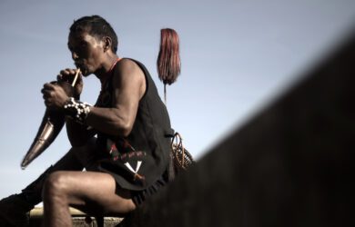
The Konyak Naga tribe inhabit Mon District – one of the most popular places to visit in Nagaland . The Konyaks stand out among other Naga tribes for their unique cultural markers, including elaborate facial tattoos, which were traditionally earned as a rite of passage following successful headhunting expeditions. The Konyaks were the last Naga tribe to stop headhunting. Here you can see traditional Naga tattoos and attire – perfect for photographers! See the Konyak Tea Retreat for more.
At Nagaland’s Hornbill Festival, the Konyak, along with the 16 other major tribes, showcase their traditions, culture, costumes and cuisine. Launched in the year 2000, the festival is a vibrant celebration of food, dance and music. It also doesn’t take itself too seriously. Amongst the rich cultural heritage, expect performances by local rock bands and King Chilli eating competitions!
The best way how to reach Nagaland is by flying into Dimapur. There are regular flights from Kolkata (West Bengal) and Guwahati (Assam). Trains from the rest of India, often via Dibrugarh (Assam), terminate in Dimapur. In theory it is possible to drive into Kohima from Manipur to the south, but this road is often disrupted. The best time to visit Nagaland is between November and April.

Dr Robert Lyman explores the events of WW2 in Kolkata, Kohima and the Naga Hills.
Trek from the plains of Dimapur up to Kohima in the hills. Stay overnight in Naga villages.

Hiking through the Naga Hills, in the footsteps of Naga soldiers, with Charlotte Carty.
